Sunday, 6 June 2010

Stackpole Sea Kayak Festival

Just a few photos from a fantastic event. The weather was kind, the scenary stunning and the company great.

Launching at Porth Clais
Playtime

One of the youngest participants, at 11 years old

Loads of boats

Friday, 21 May 2010

A Quick Lap of Walney

This trip was last minute planning at its best. One minute I was wondering what to do with a day off work and a good forecast, the next, I was wheeling my boat down to the far distant sea at Earnse Bay on Walney Island. Tides were good for a circumnavigation, so I set off southbound, with tiny wavelets lapping my boat from the side and the ghostly silhouettes of the windfarm turbines appearing out of hazy murk in an ever changing succession of transits. There wasn't a lot to see. The west side of Walney is low lying sand and pebble shore topped with flat grass. As I approached Hilpsford point a couple of wooden groynes broke the monotony and the tide began to make its presence felt as I was quietly given a helpful shove.

Round the corner I was met by a beach black and white with eider and oystercatcher. I managed a quick snap of a sandwich tern and was then followed by a large contingent of seals.

Once I'd 'done' the nature reserve I started the slog up the Walney Channel to Jubilee Bridge, where I met some intrepid open boaters who had abandoned the dry rivers and ventured onto the sea though I imagine that Walney Channel has a lot more in common with rivers than it does with most sea areas.

In no time at all I was rounding the corner at Lowsy Point and turning the boat southwards to get the circuit completed. Landing directy onto the slipway at Earnse cost me a welly full of water but did at least mean a short walk to the car.


Saturday, 24 April 2010

Conwy to Puffin Island

Beautiful high pressure weather saw a huge flotilla of NWSKers descending on Conwy to launch beside the marina into the rapidly ebbing mouth of the River Conwy. The plan was to have lunch on Puffin Island and return via Great Ormes Head.
The seals on Puffin Island weren't bothered by our proximity as they basked in the sunshine

Kev managed to catch his dinner, ready for barbecueing later.

After lunch of jam and cream scones at Penmon Cafe, six of the party decided that a direct return to Conwy was in order, the remaining six set off at a brisk pace for Great ormes Head where a little speleology was in order.

This is the track we paddled, a total of 36km.

Monday, 19 April 2010

Circumnavigation of the Land of Tide Races

Following John Willacy's superb effort and smash of the Anglesey Circumnavigation record last year, I began thinking about records for women. A little research unearthed a time of fourteen and a half hours by Justine Curgenven and Fiona Whitehead for the same journey. I like the purity of a solo attempt so this is my main goal.

The following account is the story of my training, the tidal planning and ultimately the attempt itself.
The plan was hatched in the middle of winter. It was cold and frosty, snow was forecast, so I got my boat out. I don't really believe in the idea of a paddling season. I just put more clothes on when it's cold and get on with it.

Anglesey has everything in the tidal planning textbook. There are conventional 6 hours each way tides, there are floods stronger than ebbs, ebbs stronger than floods, inshore flow that starts before offshore flow, offshore flow stronger than inshore flow, tide races on many of the headlands, eddies behind headlands and then there is the Menai Straight where all rules are broken. A circumnavigation attempt can fail at the planning stage so I spent many happy hours poring over books, charts and maps, safe in the comfort of my living room.

The first decision was which direction to go in. That was the easy bit. The flood on the west and north coast is stronger than the ebb, while the ebb is stronger in the Menai Straight. Clockwise has to be the faster option.

The next dilemma to work out is the starting point. First I identified the crux section, which I took to be the transition from flood to ebb at the entrance to the Menai Straight. If this bit goes wrong I end up paddling uphill, just when I'm 3/4 of the way round and absolutely shattered. I'm also keen to be in the Straight, where the shore is never far away towards the end of the attempt.

I'm keen to do as little paddling in the dark as possible. Spring floods tend to begin in the small hours of the morning leading to a pre-dawn start on the west coast. The area between Llanddwyn Island and Rhoscolyn has very little flow close inshore, so starting here in the last few hours of ebb could be a good plan, getting me to Rhoscolyn, just as the flood is beginning. This way I can make full use of the flood round Penrhyn Mawr and the Skerries and as far as possible towards Puffin Island.

My sources of tidal information included the tidal stream atlas in Ralph Morris' 'Cruising Anglesey and Adjoining Waters', Terry Storry's 'Snowdonia, White Water, Sea and Surf' and the diamonds on the Admiralty charts. Terry Storry's book (sadly out of print and hard to come by)had the most detailed information regarding tidal streams close inshore. I had also done some home research on many previous trips to Anglesey.

Finally I drew all over a map of Anglesey, a black line for my estimated paddling speed of 7km/hr and a red line for the expected tidal assistance for each hour of the journey. This method gave me an estimated time of fourteen hours for the whole trip. It certainly looked feasible.

As far as training goes, I didn't do anything special in preparation for this attempt, just went out paddling as often as possible. I tend to focus on technique more than fitness and so every trip I am constantly working on efficient forward paddling. I use a wing paddle which I think makes it easier to generate a good efficient style, in that the paddle does a lot of the work for you.

There is no such thing as a low angle stroke with wings!

Planning dictated a 5am start and I was already beginning to regret the whole idea as the alarm reverberated around my trusty paddle waggon, in which I had been sleeping. It was the middle of the night. Reluctantly I got up, dressed and breakfasted and got ready to face the challenge.


Pitch black, and I'm going paddling, alone, how daft can that be? I certainly felt a little daft as I set out for Rhoscolyn Beacon without a clue as to where Rhoscolyn was. Eventually I made out the lights of the nearby village, so set off for a point just to the left of the most westerly light. What little night vision I had was instantly spoiled every time I looked up. The floodlights at Valley Airfield are certainly bright.

Just as I began to feel the helpful pull of the tide, someone switched the lights on and dawn had dawned. Rhoscolyn beacon was right in front of me and I was already ahead of my schedule. No stopping, straight to Penrhyn Mawr with the tide accelerating all the time. The tide race was running with waves over my head and one that helpfully broke over me sending gallons of water straight down the open neck of my cag. Great, I had no plans to stop en-route so was destined to spend the rest of the day in wet fleece, lovely. My paddling speed briefly reached 15km/hr then plummeted as I ploughed through an eddy. It took nearly a kilometre to get back to a decent speed. I was keen to avoid these eddies as I needed all the help I could get to get the journey completed. In comparison, South Stack was flat, fast moving but flat. I shot past the lighthouse and on past north Stack, staying well out into the current. In the haze of early morning I couldn't make out the Skerries or Carmel Head so I just set off for where I thought they should be and hoped that I wouldn't get it wildly wrong. Just as Carmel Head was making its presence known, I saw the Langdon Bank buoy, and shortly after, crossed an area of decidedly funny water. This was fun. By now I was well into my stride and initial aches and pains had gone, the sun was burning through the mist and I spent a wobbly minute or two delving into my day hatch to exchange woolly hat for sunglasses.

The north coast seemed to fly by. Tidal assistance was great and progress was marked by a quick succession of mice, approximately forty minutes from West to Middle Mouse and a further forty from Middle to East Mouse. At Point Lynas, I thought I was paddling well offshore in order to keep out of the eddy that forms behind the point. The GPS track shows that I was nowhere near as far out as I had planned. Still, I think I avoided the eddy.


The section from Point Lynas to Puffin Island was hard. It took me two and a half hours to cover the twenty kilometres and it was unremittingly boring. I was half way across before I could even see Puffin, so most of this section was paddled on a bearing. With no coastline close by to change the view I had to resort to crazy tactics to maintain some form of mental stimulation. First of all I tried counting paddle strokes. That was about as exciting as watching paint dry. Then I measured how far I moved in 100 strokes and calculated how many strokes to Puffin Island. The result, 4000 was depressing. Then I tried guessing when I had covered a kilometre. To start with I was fairly accurate but as I got more tired my guesstimates got shorter and shorter. For a while I used my tried and tested technique of self-coaching my forward paddling style; ten minutes of concentrating on my feet, ten minutes getting the catch further forward, looser grip on the paddle, more movement on the seat, less splash and so on. Eventually, what had been a tiny pimple on the horizon turned into Penmon lighthouse and on the rocks beside I saw David, my boyfriend. This cheered me up no end as I sped past with just a few words exchanged.


Tide in Puffin Sound was against me, but the high water level meant there was a big eddy close to shore and I was able to blast through into the relative calm of the Menai Straight. At long last the easterly wind was now in my favour. The tide was fairly slack but the wind made some good waves to surf me along the way. As I approached the swellies I felt like I was on an ever accelerating conveyor belt. The speed was exhillarating as the GPS touched 19km/hr, I was flying!

Speed remained good all the way down the Straights. The proximity of the shore and changing view was enough to relieve tired arms and my only real suffering was a huge blister on my left hand. This was all to change as I emerged from Abermenai Point and directed my bow towards Llanddwyn Island. I came to realise how sheltered the Straights had been as a sharp NE wind hit me from the side. With skeg down and gritted teeth I continued the mission.

The last twenty kilometres were unremittingly tough. The strong wind forcing a closer inshore route than I wanted, adding a couple of kilometres to the total. Finally the finish beach was in sight, and I even managed a bit of a sprint to the end, and a very welcome stopping of the watch at thirteen hours and eight minutes.


David was there with my portage trolley, and gallantly trailed the boat up the beach for me as I staggered along behind. I was very pleased to see him.

Saturday, 27 March 2010

NWSK Start of Season Meet - Holy Island

I haven't yet come to terms with the idea of a start and end of the paddling season, but a weekend in a bunkhouse on Anglesey is too good to miss, especially when there will be thirty other paddlers there along with more pizza than we could possibly eat (thanks Kev).

On Saturday the forecast was for NW force 4, and the tide was such that an anticlockwise circumnavigation of Holy Island was possible with an early morning launch just a few hundred metres from base. Jimski, Barry, Glen, Jean and I trolleyed our boats to Borthwen beach and were soon heading off at a brisk pace up the Cymran Straight towards Four Mile Bridge. After a quick change of woolly hat after a near falling-in I managed to snap a few pictures of birds in the Inland sea.

At Stanley Embankment we were forced to stop for a second breakfast while waiting for the tide to stop flowing in, or alternatively a bit of play time.


Once in Holyhead Harbour, a quick radio call confirmed we were unlikely to be run over by a Sea Cat ferry. Still, we stuck close together to give boats a good chance of seeing us and made our way rapidly towards the relative safety of the open sea and the conveyor belt that leads to North Stack. Owing to HW in the Inland Sea being an hour after HW Holyhead, and North Stack begining to build up an hour before HW Holyhead, it was in fine form as we reached it. A moderate north westerly wind may have added to the fun too.


After all the fun of the race we were in need of another food break, and where else but Parliament Cave. Entertainment was provided by a group of climbers abseiling in, in preparation for a gravity defying ascent of cliffs to the north.

After relaunch it was a mixture of rockhopping, and short-cuts across bays until a group of tired paddlers made it back to Borthwen and copious cups of tea at the bunkhouse.

Thanks to Glen, Jean, Jim and Barry for a fun day out.


Tuesday, 16 March 2010

Sunny Anglesey

With a week off work and the promise at the end of it of a good weekend paddling with the folks of the North West Sea Kayakers there was nothing else to do but load up my trusty custard coloured paddle wagon and head for the island where the tide races rule. As usual I had no plans, but as I drove past Conwy and looked across at Puffin Island an idea was forming. This was to be a week of gentle paddling in glorious sunny conditions.

Puffin Island trips are always good for wildlife photos and this one was no exception. I had a new camera to try out and the conditions were calm enough to use it while on the water.


After a comfortable night in the paddle wagon, I awoke to a sea view and thoughts of a gentle paddle along the north coast. I put in at Portheilian and made my way past Amlwch and Bull Bay to the old brick factory at Porthwen. On the return journey I hugged the shore and had a great time rockhopping around Bull Bay, where normally strong eddies keep me offshore. The tempting narrow gaps between rocks were asking to be played with.

This is probably my favorite wild camping spot on Anglesey. Why, why do people have to spoil it with huge fire circles? Whats wrong with building a fire on top of an already scorched bit of earth?
A much photographed arch, usually with a yacht through the gap.


I drove over to Porth Dafarch, intending to use the back of the beach as a quiet spot for the night when paddlers I knew turned up for a bit of after work sport at Penrhyn Mawr. Quick as a flash, I was back in my kit and out on the water for the second trip of the day. A play in the last of the flood at Penrhyn, a sprint to South Stack and then a rock-hop in the dark to return.


Next day I opted for a gentle bimble from Porth Dafarch to Rhoscolyn and back, rockhopping all the way. This 'lightweight' paddle was in preparation for an evening paddle to the Skerries. Three of us set out from Holyhead Harbour as the daylight was starting to fade. It was mid flood on a neap tide. Initially we just set off aiming a little to the left of the Skerries, later when it became obvious that we were in danger of missing our target, we changed direction and aimed more towards the west cardinal mark of Langdon Ridge. The GPS track showed that we made a remarkably straight course. On approaching the Skerries the tide quickened appreciably and there was a sizable tide race directly between us and the relative calm of the lagoon, our intended landing spot. What fun! Had our tea sitting in the shelter of the lighthouse escaping the biting north easterly wind before setting off on the return journey in darkness.


It was somewhat eerie paddling in the dark, with the remnants of the flood tide pushing us inshore and the light from the Skerries lighthouse reaching out in a double sweep every ten seconds from somewhere behind us. The lights of Holyhead and the navigational marks in the harbour gave us a big target to aim for and it wasn't long before we were inside the breakwater sprinting the last bit. A fantastic experience paddling at night, and one I hope to repeat soon.


GPS track of our route out and back

Next day, conditions were a bit 'chunky' as Barry and I set off from Porth Dafarch towards South Stack. The wind was north westerly and tide was ebbing. At South Stack we had a tentative look at the state of water in the gully and made a quick about turn to go round the island. As we stuck our bows out of the relative shelter I can only describe the sea as 'exploding mountains'. It didn't take many minutes to decide that this was not going to be an enjoyable paddle so we changed plans and went rockhopping round the shore back towards Penrhyn Mawr.

Caves just have to be explored


It was all a bit frothy


Finally after a long lunch break to let the flood get started, we went for the obligatory play at Penrhyn Mawr


Monday, 22 February 2010

A Wight Knuckle Ride

I’m a self confessed ‘Islandaholic’. I love islands. I’m not sure I have reached the required degree of insanity to consider the UK a paddle roundable island – yet, but smaller islands are always in my sights.

The Isle of Wight is no exception, and when the opportunity arose to spend a week there (ok, so it was in February, but it did include a spring tide, of sorts) there was really only one plan for my paddling.

Circumnavigating the Isle of Wight is as much an exercise in tidal planning as it is an endurance event. Get it right and you have a favourable tide all day, wrong and its like going up the down escalator.

High water (Portsmouth) dictated a pre-dawn start at the western most end of the island. My plan was to do the Channel coast first and then the Solent coast on the ebb, getting the exposed bit out of the way first. The wind was forecast to be ‘variable 3 or less’ which translated as ‘in my face all morning’.

I've divided the coastline up into very roughly equal quarters.

Colwell Bay to St Catherine’s Point


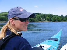
I was up at 4.45 am in readiness for a 5.30 start. It was pitch black and more than a little eerie launching into the blackness. At this point I felt really alone as I pointed my boat towards the occulting light of the Needles Lighthouse. There were plenty of navigational marks against which to measure my progress and it wasn’t long before I was looking at the giant stacks that make up the needles. The first gap was high and dry so I headed straight for the second, to be met by a considerable tide race against me, and then, crunch, where was all the water? A bit of fast manoeuvring and all was well. Light was just beginning to materialise, though my eyes by now were well accustomed to the dark.

First light as I approach Freshwater Bay


The section from Freshwater Bay to St Catherine’s Point was a series of low, crumbling cliffs, famous for the fossil dinosaurs within, but for me, memorable for the succession of headlands, each of which I thought to be St Catherine’s, only to be disappointed as another appeared beyond. This was as cruel as the false summits on a mountain climb. Thick haze reduced visibility so that I could never be sure there wasn’t another headland beyond the one in front of me. Biggish surf waves came at me from the side with no obvious warning. This was incentive to stay awake and alert if ever I needed one.

Sun appearing over one of many headlands that weren't St Catherine's


When I finally reached St Catherine’s Point I was in no doubt as to my location. The squat little lighthouse and tide race gave it away. I had hoped for a little more of the tide race, especially considering I had reached it at mid tide, but I made do with what there was, and my speed increased noticeably.

St Catherine’s Point to Foreland

I failed to make best use of the flow at St Catherine’s and kept close to the shore into the ‘doldrums’ of an eddy as I made my way towards Ventnor. This section of the journey is, for me, dominated by the direct crossing of Sandown Bay to the magnificent white of Culver Cliff. It went on forever, the monotony broken briefly as I passed close to an anchored ship. On reaching the white cliff and regretting not wearing sunglasses I was looking forward to a short bimble to Foreland, and another milestone passed. It was not to be that simple. On the corner of the cliff I was met by a strong tide race against me, requiring a big ferry glide and expenditure of a lot more energy than I was ready for. The last 3 km to Foreland seemed to take forever. I was pretty tired by this point.

'So near and yet so far', It looks close but took me ages to get to the corner


Foreland to Cowes

From Foreland to the site of the new Bembridge lifeboat station, less than a kilometre on the map, I failed to find any favourable tidal flow and floundered around at about 4km/hr for what seemed like ages. Things improved by the time I reached St Helen’s Fort, and I was soon zipping along at nearly 10km/hr. As my speed picked up, so did the amount of shipping. I had to pass Ryde pier, where the Sea Cat fast ferry arrives and departs at incredibly short intervals. Just to make it more interesting, the hovercraft ferry lands just beside the pier. I felt a bit like a hedgehog crossing a motorway. I stayed well offshore approaching Ryde to avoid the shallows, and then continued offshore all the way to Cowes. Flow was fast and I made good time.

I really didn't want to get run over by one of these.


Cowes to Colwell Bay

By the time I crossed the mouth of the Medina river at Cowes and avoided ferries, Sea Cats and gin palaces I was into the final hours of the ebb. My speed slackened noticeably, now this could have been because I had been sitting in the boat for more than nine hours already, or it could have been because I had run out of tide. Maybe a bit of both. The final section of my little adventure seemed to take forever and I finally reached my starting point twelve hours and fifty minutes after I had set out.

Dusk as I slog my way against the early flood to complete the trip


As I landed on the soft sand beneath the slipway, I fell in the water as my legs were unable to support me. How daft I felt, staying dry for 92 km of paddling and then falling in in the last metre. How I wished for someone to be waiting for me, to help carry my boat to the car, but no, this was a solo and unsupported effort, so I strapped the boat to its trolley and lugged it to the car.

I think I paddle better when I am on my own. In company, there is always a pressure to keep up with someone else, or to have to wait for someone slower. I like to set my own pace and then stick to it. I use a GPS as a speedo so that I can keep check on myself, and also keep track of how much tidal assistance I am getting. During the long featureless sections I employ a range of tactics to keep my mind working. I count strokes and then work out how many strokes to a kilometre. Then over the next three of four kilometres I test this out and work out an average. This figure of course changes depending on how much tidal assistance I am getting, so I repeat the procedure several times. I also like to try and predict what time I will arrive at a point in the distance. Then sometimes I coach my forward paddling technique. I will concentrate on one particular aspect of the stroke for ten minutes, then move onto a different aspect. I can continue this for at least an hour. Every time I start a new ten minute block my speed goes up, then gradually over the ten minutes it reverts to a baseline of about 7km/hr.

This is by far the longest paddling day I have ever done, but I hope will be the first of many long trips. I paddled the day after a small spring tide. It would certainly be a quicker trip on a better tide. Wind was forecast to be variable force 3 or less and I would estimate that it was SE force 2 most of the day. It was dry and sunny with an air temperature of about 5 degrees. My Cetus LV performed fantastically well. It is fast and holds a straight line very well, but is still manouvrable and fun in lumpier conditions. I found the cockpit comfortable even after nearly thirteen hours without getting out.

Watch this blog for further long trips and circumnavigations in the future.