Monday 30 November 2009

Spurn Point

This was a short paddle along an unusual bit of coastline. Spurn point is a long, narrow heap of sand that protects the mouth of the Humber from the lumpiness of the North Sea. The scenary was somewhat monotonous, being just a heap of sand, punctuated periodically by the remains of wooden groynes. The groynes had been built in a vain hope that a few bits of felled timber could halt the natural cycle of erosion and deposition that had occured before Man interferred. Needless to say, nature is winning and the fortifications are decaying.
Just off the point, sea conditions became more interesting and I was drawn like a magnet towards the overfalls.
This trip has the advantage of starting at a cafe and finishing at a pub. The two are about half a mile apart and the short walk to collect the transport was a good way to warm up on a cold day. The two establishments could not be more different. The cafe was very welcoming, the owner chatty and friendly and the food and drink good. The pub meanwhile has a very frightening landlady. I got shouted at for daring to suggest that the brown aqueous solution I had been served as coca-cola was in fact flat. I think I will give this one a miss in future. The only good thing about the pub was its proximity to the get-out. Here the pub is in the background as I put the Cetus through its paces in preparation for returning it to P&H.


Posted by Picasa

Sunday 29 November 2009

A sneaky day in the sun

A sunny day in the winter is something special to be savoured, and where better than The Skerries. As we set off from Cemlyn bay in the final hour of ebb the rocky islets and lighthouse looked deceptively close. About a knot of tide assisted our progress and it wasn't long before we were circumnavigating, then landing on the islands. During lunch the tidal flow slowed and by the time we relaunched the flood was well underway, especially close to Carmel Head as we were to discover while trying to cross the short gap to the headland. The return journey to Cemlyn was straightforward, following the shore with a bit of rockhopping for good measure. It was fantastic to be out on the water in such good weather after what seems like weeks of continuous rain. The picture says it all.


Posted by Picasa


Sunday 15 November 2009

Launching the new boat

Having unwrapped layer after layer of plastic and cardboard and revealed my new boat in all its red and white beauty, I didn't feel I could consign it to the shed straight away, so she spent a fortnight in my living room. It made getting to the kitchen a bit of an obstacle course, but it did mean I could admire the unmarked shining gelcoat.

Finally, work was done for the week and I could go paddling. The first launch was at Trearddur Bay on Anglesey. The weather was too rough for real paddling so we had to make do with a bit of surfing.

The Cetus LV is lovely and light, an easy one person carry.

Here's the moment I had been waiting for.

And finally afloat.


A few wobbly moments later and I was getting used to a lovely lively boat.

photo by Jim Krawiecki

All in all I think it's a grand boat. It's fast, and narrow just where the paddle goes. It's incredibly manouvrable, and whilst it's happy sitting up on an edge, it doesn't really need a lot of edge to turn. I think I'm going to really enjoy paddling it. Just need some decent weather to give it a good run out.

Sunday 13 September 2009

Another Lap of Jura

This time, I had company. I paddled with Rob, whose culinary skills would give Delia Smith a run for her money, and his mate Tom. Tom turned up with his brand new, never been on the water Scorpio (still had the price tag attached!) while Rob had begged or borrowed an elderly Capella. I paddled a borrowed Cetus, and while I found this boat too big around the cockpit area for me, I was very impressed with the way it handled while full of expedition gear. It was a bit like a tardis when it came to packing. The gear just kept going in the hatches and they never seemed to fill up. Another bonus was the sweetie hatch on the front deck, big enough for hat, VHF, sunglasses and sweets, and all within easy reach.
The Cetus, superb load carrier, highly manouvrable and fast.

We set off from Craignish Point, beyond Ardfern on Wednesday morning, following a day of stormy weather on Tuesday. Although now fairly calm, there was still plenty of evidence of previous high winds. We launched into the full flow of the Sound of Jura ebb, which carried us rapidly south as we made the crossing to Jura. There was plenty of turbulent flow along the way and it kept us awake just working out which direction we were actually moving in. Thank goodness for the GPS.

On day one we managed 30km, initially with significant tidal flow in our favour but ending with a noticeble contrary flow. We camped at an unusual site, with perfect short grass and shelter, between the walls of Lagg Pier. What impressed me most about this trip was the number and variety of animals we saw. This fellow wasn't bothered as I walked past on my hunt for fresh water.


Jura is an island with an enormous population of deer, believed to be around 6000, while the human population is a mere 180. We saw deer all over the place, and in particular on the beaches along the west coast.

On day two we got away early, keen to have a favorable tide all day. We found the paddling to be more interesting than further north as the headlands and islands are more frequent and break up the distance better. The Jura hotel provided a mid-morning break, and while we sat outside enjoying the coffee we observed that the ratio of staff to customers appeared to be similar to the ratio of deer to locals. We were vastly outnumbered.

Jura Hotel, distillery and stores from the water. This is Craighouse the population centre of Jura.

After coffee, we set off towards the Sound of Islay and had an enforced long lunch break as we waited for the tide to begin flooding. Not long after, we were shooting along at 13km/hr looking for a camping spot. We decided to make to most of the flow and camp only when we felt the tidal advantage to be lost.

Next morning we awoke to flat calm sea and little breeze. For the whole of the west coast we had amazing rocky scenary and flat conditions so we could really appreciate the cliffs, arches, caves, deer, sheep and goats.


Seaweed eaters along the shore.


After another stop to collect firewood, we ended out third day paddling at Glengarisdale bothy. This is a gem. It was great to have a night away from the midges where Rob could demonstrate his culinary prowess. It also left us within easy striking distance of the Corryvreckan. We planned to paddle 'the Gulf' at the start of the ebb, when flow should be minimal.

Our final day paddling dawned calm and dry and we set off in good time to reach the Corryvreckan at the appointed hour. Rob had been watching videos on You tube and had an idea that the 'C' would be a maelstrom of whirlpools, turbulence and general nastiness. I tried to reasure him that it would be an anticlimax but he didn't believe me, that is until he saw it, flatter than the proverbial pancake.


It was just a flat paddle across the Sound of Jura to Craignish, and Rob's van at the end of our journey. There is something very satisfying paddling all the way round an island. A sense of completeness. This trip has given me an idea for a theme to next years paddling. I'm going to see how many islands and island groups I can paddle round.

Saturday 22 August 2009

A Constellation of Starfish?

What is the collective noun for starfish? This little piece of trivia might have been very useful to me this morning as Jimski and I went for a dawn paddle at Roa Island. We were searching for an elusive pair of islands called St Helena and the Falklands and a sand bank called South America.

Making the most of huge spring tides we launched an hour before low water in the hope of finding and circumnavigating these only to be found at low water South Atlantic gems.

After a short paddle, we find ourselves landing on St Helena.


Found the odd starfish. I thought this one looked pretty on Jim's boat. Hmm starfish on boats...think someone else might have thought of that first

The starfish take a liking to Jim's feet. Is there any such thing as a man eating starfish?

Then we found a few more.


Jim on the summit of St Helena.

Jim on the highest point in South America.

After a search, we concluded that the South America sandbank had moved and was now covering the spot where we though the Falklands should have been. It's not the first time South America has captured the Falklands is it?

After a well earned breakfast at the Bosun's Locker at Roa Island, we had a look at the tide by the lifeboat station. Quite impressive!

Jura, and the big 'C'

Having tried, and failed to find anyone else wanting to go paddling, there was no choice but to have a go at a solo trip. I've never paddled solo for more than a day at a time, so this was to be a first for me.

I set out in the late evening sunlight onto beautiful flat calm sea, the land in the distance being Jura, my target for a circumnavigation.

Found a lovely little camp site, just big enough for one tent. The resident deer kept popping their heads over the hillside to see what was going on.

Next morning the sky was gloomy, threatening rain. I packed and launched in record quick time as it took the midges about a minute to find me once I opened up the tent. My plan for the day was to set off south down the Sound of Jura and just see how far I could get. In my haste to get ready I decided that breakfast could wait. I wanted to make the most of the tidal flow in the first half of the ebb.

This is what the view looked like for most of the day.

I plodded on and on into a fairly strong headwind. Then the heavens opened and the rain came down in lumps. By now I was hungry, cold and tired. It took me ages to find somewhere to land. I ended up squashed into a cave like niche in the base of a cliff to get what little shelter was available. I heated myself a tin of baked beans and made a mug of coffee. My little luxury for this trip was a single mug sized coffee percolator, Jimski's idea, and one that I was very grateful for.

After what seemed like forever I finally turned the corner into the Sound of Islay. I had been navigating from memory as I discovered I had lost two of my laminated map sheets along the way somewhere. I arrived at the Sound of Islay with the flood tide pushing me along at an ever increasing speed. After a whole day of strong headwind, and latterly little tidal assistance, the boost was tremendous.

At last, some shelter from the wind in the Sound of Islay.

My little luxury.
Woke up next morning still keen to paddle despite the 50km day yesterday. Shortly after setting off I had an audience on the beach.

Rock scenary was spectacular. Lots of cliffs and caves, and the occasional arch.

Had lunch at the bothy at Ruantallain, on the north shore of Loch Tarbert. A small bothy, but very welcome shelter.

Had another fairly long paddling day in order to reach the bothy at Glengarrisdale. It was sunny as I arrived and the setting was spectacular.


Spent a very creepy night in the bothy by myself. This bothy is very well equipped and only about 100m from the shore. There are two rooms downstairs and a loft with hammocks made of fishing nets. A wonderful place.

This left me a short paddle the next day to reach the Corryvreckan, a tide race with a fearsome reputation, no doubt deserved but not while I was there. I arrived about two hours into the East going flow and found it moving but mainly flat. A school of porpoises lingered at the downstream end of the race, presumably waiting for the food to come to them.

All I had left to complete this trip was a massive ferry glide across the Sound of Jura back to my car at Ardfern and a well earned meal at a local cafe.

Tuesday 28 July 2009

Easter 09, Gigha

Easter 2009 saw four of us setting off to Scotland with no real plans where to paddle. The weather forecast was so gloomy that there was some doubt as to whether we would paddle at all. We aimed for the Mull of Kintyre and ended up camping on the shore close to Claonaig, where the ferry departs for Lochranza on Arran. For the next two days we visited every castle and tea shop between Tarbert and the southern tip of the Mull. There is a limit to the amount of tea I can drink, and just as we were all feeling a little washed out the forecast started to promise improvement.


Gloomy skies and wild seas greeted us each morning.


We awoke on the third morning to find that reality matched the prediction and we could at last get afloat.

A friendly hotel at Belochantuy provided parking and an easy launch spot. Conditions were not calm, but forecast to improve so we packed for an expedition and set off. The plan was to head north along the Kintyre coast until the narrowest part of the Sound of Gigha. The weather was out to prove that it was in charge again and with what looked like a storm approaching we made the crossing to Gigha as fast as we could. Safely over the Sound we were deluged by a short, sharp shower. Rain that came down in lumps and stung the face if you dared to look up. It didn't last long but wasn't pleasant and the temperature dropped noticeably.

Next we had to find a campsite. We landed on Gigha about an hour before high water on a particularly big spring tide, all the best looking spots were threatened with innundation as the tide rose. Eventually a passable spot was found. Not ideal but it would do. I was cold and tired and didn't really care.

I'm sure Gigha has lots to offer the pedestrian explorer, but for this visit it remained unexplored. Next morning we awoke to blue sky and sunshine - what a change! Launching had to be done in a hurry as the sea retreated.

We set off on an anticlockwise curcumnavigation.

Every nook and cranny of the island was explored including the wreck of the Russian factory ship 'Kartli' which ran aground in 1991.

We ended up heading for the island of Cara to look for a camping spot. Conditions at the southern end were lumpy, a mixture of swell and clapotis making a confused mixture of waves and lumps. Nick and Ali in their double found this quite difficult. I guess Ali had a wetter ride that we had in our singles.

The camp site made up for any difficulties getting there. Flat grass right beside a short sand and pebble beach, with a grassy bank between us and the southerly wind and as if that were not enough, an abundant supply of driftwood.

Plenty of firewood, whisky and chocolate made it a memorable evening.

Next morning we had no option but to return to out cars at Belochantuy for the long drive home. This was a short, but lovely trip away. My first camping trip of the year, and I hope the first of many.

Crossing the Minch, Sept 08

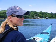
I’m not sure if it was a brave or foolhardy thing to do. With hindsight and success I found it exhilarating and got a fantastic sense of achievement. Things might well have gone differently. What did I do? I paddled across the Minch, the long way, from Lochmaddy to Uig by myself, a total of 48km or 30NM.

I spent a long time beforehand weighing up the likely ‘what ifs’.
-what if I fall in?
-what if I get too tired?
-what if I get injured?
-what if it gets foggy?
-what if I get run over by the ferry?
Most of these I was happy I could solve, but I did realise that I was dependant on the ferry having a good lookout. Finally I had no more excuses. I had just another three days before I was due to leave North Uist after a summer season working at Uist Outdoor Centre. I studied the various weather forecasts ad nauseum. I didn’t just need light wind and good visibility; I needed to know that it would last all day, with no nasty surprises just when I was getting tired.

As time was running out, a possible weather window appeared. While England was experiencing whole months worth of rainfall in a single day, and homeowners were baling out their living rooms, I was setting off from Lochmaddy in glorious sunshine.

The water was not the flat calm that I wanted. The plan was to paddle out into the Minch and see what conditions were like. I kept telling myself that I could always turn back if I didn’t like it. The centre was quiet and deserted. No one saw me leave and this added to the sense of isolation I felt later. I left a note of my intended journey for the others to find when they got to work. With a cheery ‘Good Luck’ from the coastguard I set off.

Four kilometres paddling got me to Madadh Beag, or ‘Little Hound’, one of three sea stacks that guard the mouth of Lochmaddy and give the loch and village their names. At Madadh Beag I was disappointed to find out that the wind, about a force three was going to be on my starboard bow at just enough of an angle to make me think about steering all the way.

I set the GOTO function on my GPS for Waternish Point on Skye, picked a landmark on the skyline and set off. It quickly became apparent that in order to keep the bearing (intended direction) and track (actual direction) figures the same I would have to paddle a giant ferry glide to allow for the wind. With a new landmark to aim for, I set off.

The time of day that I set off was determined not by the tides but by the timetable of the CalMac ferry that was to be the return leg of my journey. I hoped to do the crossing in six hours in flat calm conditions, but had to rapidly extend this estimate in light of the unfavourable wind. Just to be on the safe side I set off with ten hours before the return ferry was due to leave. As luck would have it, my weather window occurred on neap tides, so I was expecting a maximum flow of just 0.4 knots at mid tide. Even better, the first leg of the journey was going to be either side of low water slack. My plan to keep my track the same as the bearing on the GPS would deal with the effects of wind and tide, keeping me on the shortest route.

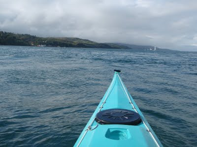
My plan was to paddle out into the Minch for ten kilometres and then make a decision whether to continue or not. I thought at that point I could easily return if I didn’t like the conditions. I tried to be disciplined enough not to keep on looking at my distance paddled, hoping that this way the numbers would seem to increase more quickly. It didn’t work. I held out for as long as I could, and then when I was sure I must have paddled at least ten kilometres, I took a look. How disappointed could I get? I had covered just four kilometres.

Going back was not really an option. I didn’t want to fail. I had set myself up to paddle the Minch and this was exactly what I was going to do. I gritted my teeth and carried on.

One possible problem that I hadn’t considered was that of boredom. It took me five hours to reach Waternish, and all the time the view barely changed. I tried singing to myself. This worked for a short time until I couldn’t remember any more words. I tried counting paddle strokes, working out how many strokes I did in 100metres, and hence how many in one kilometre. I then tested this out by counting strokes for several more kilometres. At this point I was wishing I had a waterproof ipod. A bit of music would have been a good distraction. I did get a couple of things to break the monotony though. A harbour porpoise came to say hello, arching alongside my boat close enough that I could almost touch it. It didn’t stay long, but was great to see. The second distraction was the ferry, leaving Uig and sailing to Lochmaddy, the exact opposite of my route. I could see it coming, but could it see me? I got my compass out and measured the collision angle on a number of occasions. The angle stayed the same, indicating a collision course. I changed direction, but could my slow speed compared with the ferry make any difference at all? Eventually the ferry appeared to make a slight alteration in course. This was enough to tell me that someone had seen me. I could relax a bit. In the end we passed close enough that I could make out figures on the bridge and in the passenger lounge.

By now, I was starting to make out features on the Waternish peninsula. Small white blobs surrounded by grass which I had previously thought were sheep turned out to be the houses of a village. How wrong can you get? Eventually the white spot on the headland revealed itself to be a lighthouse, and a short while later, the black blob beside it became a lone walker, stopping for lunch. I was pretty keen to land by now. I hadn’t had anything to eat since setting off as I made the mistake of putting my food in my day hatch, blindly assuming that conditions would be flat enough for me to retrieve it en route. Wrong again! I found a sheltered spot to land just east of the point. I was ashore for just twenty minutes before the midges found me. Just long enough to stuff a bit of food down, change my fleece and attend to natures call. I felt revived as I got back in my boat. The last five kilometres had been very hard and I really felt that I was running on empty fuel tanks.

For the first part of the next leg I had a coastline to follow. It made such a difference to have a changing view and an obvious clue that I was making progress. I guess I was getting distracted by the novelty of cliffs and the shoreline when I was brought back to earth with a jolt, or rather, a spine jarring scrunch as I failed to notice the gelcoat splitting rocks just below the surface. I winced as I thought of the scrapes on the hull and started to pay a bit more attention.
The Ascrib islands quickly got closer, and I was able to make out an impressive looking house on the Southern most Island. The sea was soon dotted with hundreds of inquisitive
heads all pointing in my direction. I had disturbed a seal colony as they lay hauled out on the rocks of a nearby skerry.

The final leg of the journey to Uig seemed endless. I could see my target but it wasn’t getting any bigger. I guess when I reached Waternish I had switched off, feeling that the crossing was over. In fact at Waternish I was just a bit over half way to Uig. By now my arms really felt like they were about to drop off. My paddle felt like lead and every bit of me hurt. The jolt back to reality came when I tried to lift my boat from the rocky spot where I landed up to the pier, a distance of about fifty metres. It took me forever. At last, with the boat on the pier, I went to the CalMac office to get a return ticket. On the ferry, I bought the biggest meal the canteen could offer and then fell asleep for the rest of the crossing. At Lochmaddy, my boat was carried from the ferry for me by a couple of crew members who had last seen me in the middle of the Minch.

All that remained to do was drink a celebratory dram with my boss. It was well earned.

Walney Circumnavigation, July 09

This felt like the shortest twenty mile paddle ever. The North West Sea Kayakers circumnavigate Walney. We had everything we wanted, spring tides, a warm calm day and good company. What could be better. Seven of us set off from Earnse a couple of hours after low water. This of course meant that the sea was miles away but we all had trolleys, and the certainly made light work of what would have been a horrid carry.


As soon as we were floating we could feel the effects of the tide. Winds were so light that the turbines were hardly moving. They look really close but I understand that they are a lot bigger and further away than appears. As we approached the Southern end of Walney we could feel the tide pulling us faster and faster around the corner. Hilpsford point was marked by water rushing over a shallow sandbank, with a few fun waves to surf.


The castle on Piel came into view. An imposing view, or at least it would have been when the castle was complete. Our trip had been timed to allow us to sample island hospitality in the form of beer and bacon butties. We sat on the grass stuffing our faces enjoying the sight of the Walney chanel flowing like a river.


Once floating again and enjoying the conveyor belt like flow, we took care to keep out of the shipping lane. Just as well as next time we turned round a tug was towing a huge contraption that looked like an enormous upside down table. The four towers loomed high above the tug. We guessed it had something to do with the building of the offshore windfarm as the towers looked like they ccould be lowered into the water to act as legs. This beast went by the unlikely name of 'Pauline'. A smaller tug took over as the beast was manouvred into Ramsden dock, backwards. This was an impressive bit of precision boating as the thing never touched the sides once.


We sped on, under Victoria Bridge and on to Walney Meetings, where tide from the North meets tide from the South and it feels like paddling on porridge. We had a second lunch break watching the water flow through the narrow gap as though someone had pulled the plug out, and then went across to explore the extraordinary houses at Lowsy Point. They appear to be cobbled together from old sheds, bits of prefab buildings and all manner of other un-house like things. Some had a cladding of fibreglass to hide whatever might be underneath. One inhabitant told us they are only occupied at weekends and perhaps during good weather in the summer.


It was just a short hop from Lowsy Point back to Earnse where we started. waves were breaking over the duddon bar and a couple of nudists walked along the beach. The water was lapping close to the slipway, and an ice cream van was in situ ready for us. Perfect. This was a fantastic day out, more so because it was a day of bright sunshine sandwiched between filthy wet days.


'Pauline' under tow.

Monday 27 July 2009

June 09, a little bimble

A fine saturday in June, what else was there to do but go for a paddle? I set off from the southern end of Seil island heading towards the island of Belnahua, with its relic of long gone industry. I had no real plans for the day other than to go and see the Garvellachs. The sea conditions were calm, very little wind and a dry forecast, perfect. This is belnahua, the buildings are what's left of a slate quarry. From experience the grass is so thick that camping on it is like sleeping on a matress. It's also quite difficult to get tent pegs through it.


Next I paddled to the most northerly of the garvellachs. By now I was really enjoying the solitude and fantastic conditions. Further south along the island chain is evidence of habitation, but not as we know it. This is the remains of a beehive cell, lived in by those who believed that self sacrifice would make the world a better place.


From the southern end of the garvellachs I had to make a decision, where next? Scarba, across the way looked enticing. I had already paddled the Grey Dog, the tide race to the north of the island, and the Corryvreckan was calling me. It had been on my 'to do' list for a long time and maybe today was the day? I set off, wondering if it was the right thing to do. I had heard horror stories about what the Corryvreckan can be like. I also knew that the weather conditions were as good as I was ever going to get. I was also due to hit it towards the end of the ebb tide, when it is at it's gentlest. I decided to go for it. As I approached, my speed picked up, there may well be no going back. The water was flowwing fast but still flat, barely a ripple.


As I rounded the corner into one of the fastest tide races in the country (not at the end of the ebb, I admit) I was a little nervous. My heartbeat soon returned to normal when I discovered it was as flat as a pancake! This is what I saw.


It was so flat as to be an anticlimax. I was at least expecting to see where the whirlpool forms, or some evidence of the underwater peak that causes all the maelstrom in rough conditions. Nevermind, I'll just have to go back.
Had lunch at a fantastic spot on Scarba, at the Eastern end of the Corryvreckan. Would make a fantastic camp site. The place was liberally scattered with pink and white orchids.

The rest of the trip was a leisurely ride on the tide up the Sound of Luing, past Fladda and back to Seil. On this last part of the trip I met up with two other paddlers going in the same direction as me. Paddlers are always such friendly people, so I tagged along with them for company until they left for the slog up the Cuan sound against the flow.

All in all, a lovely trip in fab conditions. Total of 42km.